Synopsis:
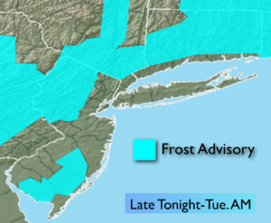
Much colder readings are with us and will stick around for the next 24 hours. A Northwest flow is bringing down the coldest temperatures of the season so far. In fact, many inland areas may see there first frost tonight. A Frost Advisory has been posted North and West of the City. You may want to bring in your potted plants or flowers tonight.
The cold high will moderate by midweek allowing the mercury once again rise to above average readings. The average high is 64º. Tranquil, pleasant conditions are expected through the Friday as a large high pressure system dominates the Eastern one half of the country. These conditions are quite typical for October.
Stay tuned.
Tonight:
Becoming mostly clear and much colder. Lows in the lower to mid 40s in the City. The 30s inland. Areas of frost North and West of the City. North winds diminishing to 5-10mph.
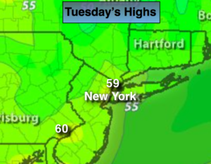
Tuesday:
Sunny and cool. Highs around 60º. Northwest winds will become Southwest at 5-10mph.
Wednesday:
Sunny. A top ten day. Highs around 70º.
Thursday:
Sunny. Highs in the lower 70s.
Friday:
Sunny. Highs in the lower 70s.
Saturday:
Sunny. Highs in the lower 70s.
Keep it here for a no nonsense, no hype forecast.