Synopsis:
A cold front moved through early this morning. Any early morning showers will end with the sun returning from West to East. Temperatures will start off below average today and Tuesday. In fact, many inland areas may see there first frost tonight. A Frost Advisory has been posted for inland areas. Tranquil, pleasant conditions are expected through the Friday as a large high pressure system dominates the Eastern one half of the country. These conditions are quite typical for October.
Stay tuned.
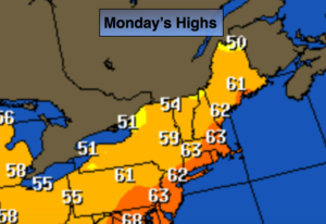
Monday:
A spotty early morning shower, otherwise becoming partly sunny, much cooler and breezy. Highs in the lower 60s. Northwest winds at 10-20mph with gust to 25mph.
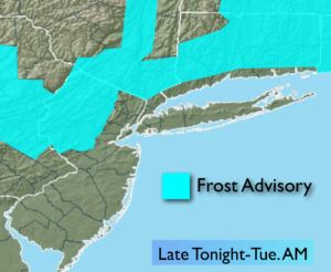
Tonight:
Clear and much colder. Lows in the lower to mid 40s in the City. The 30s inland. Areas of frost North and West of the City. North winds diminishing to 5-10mph.
Tuesday:
Sunny and cool. Highs around 60º.
Wednesday:
Sunny. A top ten day. Highs around 70º.
Thursday:
Sunny. Highs in the lower 70s.
Friday:
Sunny. Highs in the lower 70s.
Keep it here for a no nonsense, no hype forecast.