Becoming Cloudy. Late Showers South…


Synopsis:

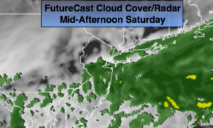
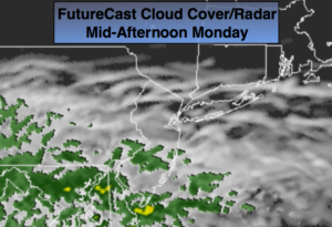
Our weather will turn grey and damp. Today will feature mainly cloudy skies (after some morning sun, especially North). A storm will develop over the Southeast. High pressure will be off the New England coast. The combination of the two may result in a bit of light rain by late this afternoon or evening (FutureCast cloud cover/radar above), mainly South of the City.  A more widespread rain event is likely Tuesday into Wednesday morning as a storm moves up and off the coast.  It will raw. The rain could come down heavy later Tuesday or Tuesday night.

The storm will slowly pull away on Wednesday. Rain will taper off toward mid-day.

The sun will return later in the week along with warmer temperatures.

Stay tuned.

Today:

Mainly cloudy skies. Sun is likely North of the City for a time this morning. Chance of showers by late afternoon or evening, mainly South of the City.  Highs in the lower 60s. East wind at 8-12mph.

Tonight:

Cloudy with areas of light rain or drizzle. Lows in the 40s throughout. East to Northeast wind at 10-20mph.
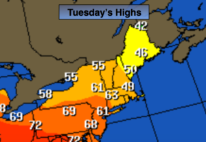
Tuesday:

Periods of rain. Breezy and cool. Highs in the lower to mid 50s.
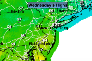
Wednesday:

Morning light rain. Remaining mostly cloudy. Highs in the lower 60s.

Thursday:

Partly sunny. Much warmer. Highs around 80º.

Friday:

Partly sunny.Warm. Highs around 80º.

Keep it here for a no nonsense, no hype forecast.


Sunday Beauty. Sunny & Pleasant…


Synopsis:

The 2nd half of the weekend will be a complete turnaround from Saturday’s grey damp skies. The sun will dominate today as a ridge of high pressure works in. It will be a beauty. Temperatures will be in the mid 60s. The average high for the date is 63º.

Monday will feature mainly cloudy skies. A storm will develop over the Southeast. High pressure will be off the New England coast. The combination of the two may result in a bit of light rain by Monday evening.  A more widespread rain event is likely Tuesday and Tuesday night as the storm moves up and off the coast.  It will raw.

Stay tuned.

Today:

Mostly sunny.  Highs in the mid 60s. Winds becoming Southeast at 5-10mph.

Tonight:

Clear. Becoming mostly cloudy by sunrise. Lows in the upper 40s in the City, near 40º inland. Winds South at 5mph.

Monday:

Any early sun will give way to cloudy skies. Chance of light rain by late afternoon.  Highs in the lower 60s.

Tuesday:

Rain likely. Breezy and cool. Highs in the lower to mid 50s.

Wednesday:

Early showers giving way to afternoon sun. Highs in the mid 60s.

Thursday:

Partly sunny. Much warmer. Highs around 80º.


Keep it here for a no nonsense, no hype forecast.


Showery Saturday. Sunny Sunday…


Synopsis:

A weak front over the region today will result in on and off showers. FutureCast radar and cloud cover above. It will not be a washout, but it will be raw. Temperatures will be below average.

On Sunday the sun will dominate as a ridge of high pressure works in. Readings will be seasonal. The average high for the date is 63º.

Another storm will move up and off the coast for the early week period with a chance of rain.

Stay tuned.

Today:

Mostly cloudy and cool with scattered showers. There will be dry times. Highs in the upper 50s. Northwest winds at 5-10mph.

Tonight:

Becoming mostly clear late. Lows in the upper 40s in the City, the upper 30s inland. Winds becoming North at 8-12mph.

Sunday:

Mostly sunny.  Highs in the lower to mid 60s.

Monday:

Sun to clouds. Chance of afternoon showers.  Highs in the mid 60s.

Tuesday:

Mostly cloudy with a chance of rain. Highs in the upper 50s.

Wednesday:

Clouds to sun. Highs around 70º.


Keep it here for a no nonsense, no hype forecast.


Morning Showers, Some PM Sun, Especially Inland…


Synopsis:

On and off showers are expected this morning as an area of low pressure moves in from the West. The sun will likely return this afternoon especially from the City on West. Clouds may hold tough over Eastern areas.

The forecast for the weekend is looking better. Saturday will feature a mix of sun and clouds as we’ll be in between weak areas of low pressure. The latest computer guidance for Sunday now has the low pressure system staying to our South and shearing apart. What this means is that most areas from the NYC vicinity and North should remain dry. South of the City a chance of light rain is possible, but it could end up being dry here as well.

Stay tuned.

Today:

Mostly cloudy with morning scattered showers. Some sun is possible in the afternoon, mainly inland. Highs in the lower to mid 60s in the City and over Western areas, the 50s over Eastern regions. East wind at 5-10mph.

Tonight:

Mostly cloudy. Lows in the lower 50s in the City, the upper 40s inland. Winds becoming North at 5mph.

Saturday:

Partly sunny.  Highs in the mid 60s.

Sunday:

Partly sunny Light Rain is possible South of the City.  Highs around 60º.

Monday:

Sun to clouds. Chance of afternoon showers.  Highs in the mid 60s.

Tuesday:

Mostly cloudy with a chance of showers  Highs around 60º.

Keep it here for a no nonsense, no hype forecast.


Unsettled Times Ahead…


Synopsis:

On and off showers are into Friday due to the combination of an onshore flow and an area of low pressure that will approach from the West. It won’t be raining all the time and there will be times of sun.

The weekend at this time looks like a 50/50 split.  Saturday will be the better of the two days with a sun and clouds. There is a chance of light rain on Sunday. The latest computer guidance has the system just reaching the area. If  this Southern trend of movement of the low continues, Sunday may end up being dry. Stay tuned.

Today:

Clouds with some sun. Spotty showers. Highs in the mid 60s. East wind at 5mph.

Tonight:

Scattered showers. Lows in the 50s throughout. Southeast wind at 5-10mph.

Friday:

Mostly cloudy with scattered showers, warmer. Some sun is possible. Highs around 70º.

Saturday:

Partly sunny.  Highs in the mid 60s.

Sunday:

Light Rain is possible.  Highs in the mid 50s.

Monday:

Partly sunny.  Highs in the lower 60s.

Keep it here for a no nonsense, no hype forecast.


Sun to Clouds, Cooler Today…


Synopsis:

High pressure responsible for our fine Spring weather will move off the East coast today. Sunny skies will be replaced by increasing clouds this afternoon. Our shower threat will increase tonight into Friday due to the combination of an onshore flow and an area of low pressure that will approach from the West.

The weekend at this time looks like a 50/50 split.  Saturday will feature sunshine. Rain is likely Sunday.

Today:

Sun will give way to clouds. Cool. Highs in the mid to upper 50s. Southeast wind 8-12mph.

Tonight:

Scattered showers. Lows around 50º in the City, the 40s inland. South wind at 5-10mph.

Thursday:

Mostly cloudy with a chance of showers. Highs in the mid 60s.

Friday:

Mostly cloudy with scattered showers, warmer.  Highs in the lower to mid 70s.

Saturday:

Partly sunny.  Highs in the lower 60s.

Sunday:

Rain likely.  Highs in the mid 50s.

Keep it here for a no nonsense, no hype forecast.


Seasonal Sunshine…


Synopsis:

Today will be a gem with  sunny skies and seasonal readings as high pressure dominates over the Northeast.  The  high will continue to influence our weather into Wednesday with fair conditions.

An onshore flow combined with an area of low pressure will approach from the West later Thursday into Friday. This will increase the threat of showers.

Today:

Sunny and seasonal. Highs in the lower 60s. North to Southeast wind at 5-10mph.

Tonight:

Mostly clear and cool. Lows in the lower to mid 40s in the City, the upper 30s inland. Southeast wind at 5-10mph.

Wednesday:

Partly sunny, cool. Highs in the upper 50s.

Thursday:

Mostly cloudy with a chance of showers. Highs in the mid 60s.

Friday:

Mostly cloudy with showers, warmer.  Highs around 70º.

Saturday:

Partly sunny.  Highs in the lower 60s.

Keep it here for a no nonsense, no hype forecast.


Mild Start to the Week…


Synopsis:

Temperatures will come down in steps early this week as cooler high pressure noses in from Canada. The cool front is hung up just South of the NYC area today.  This is responsible for the clouds and spot showers South of the City. Clouds will give way to sunshine as the afternoon progresses (FutureCast Cloud-Cover above).  Temperatures will still be well above average but not as hot as the July temperatures of Easter Sunday.

Tuesday will be a gem with mostly sunny skies and seasonal readings.

An onshore flow combined with an area of low pressure will approach from the West later Wednesday into Thursday. This will increase the threat of showers.

Today:

Clouds will give way to sunshine during the afternoon. A spot shower is possible South of the City.  Mild. Highs in the lower to mid 70s. Northwest wind at 10-15mph.

Tonight:

Clear and cooler. Lows in the mid to upper 40s in the City, the upper 30s inland. North wind at 8-12mph.

Tuesday:

Sunny and seasonal. Highs in the lower 60s.

Wednesday:

Sun will give way to clouds. A late day shower is possible. Highs in the upper 50s.

Thursday:

Mostly cloudy with showers. Highs in the mid 60s.

Friday:

Clouds will give way to sunshine.  Highs in the lower 60s.

Keep it here for a no nonsense, no hype forecast.


Summer-like Easter. Windy…


Synopsis:

Easter Sunday will be Summer-like with readings reaching into the lower to mid 80’s with plenty of sunshine.  A strong West to Southwest flow will develop-winds will gusts between 25mph-40mph. A Bermuda high to the South and a cool front to the North will be responsible for our late June-like day. Stray showers or storms are possible later today into this evening with the cool front. Much of the area will remain rain-free.

Temperatures will come down in steps early this week as cooler high pressure noses in from Canada under mostly sunny skies.  A couple of gems are on the way Monday and Tuesday.

It’ll be cooler and unsettled later in the week.

Today:

Partly sunny, windy and warm. Highs in the lower to mid 80s. West Southwest wind at 15-25mph with gusts to 40mph. An isolated storm is possible later in the day.

Tonight:

A stray storm early, otherwise mostly clear and mild. Lows in the lower 60s in the City, the 50s inland. West wind at 10-15mph.

Monday:

Partly sunny. A top ten day. Highs in the lower 70s.

Tuesday:

Mostly sunny and more seasonal. Highs in the lower 60s.

Wednesday:

Morning sun will give way to afternoon showers. Cool. Highs in the upper 50s.

Thursday:

Morning showers will give way to some sun.  Highs around 60º.

Keep it here for a no nonsense, no hype forecast.


Decent Holiday Weekend. Summer-like Easter…


Synopsis:

The weather will cooperate for the Easter Holiday weekend. A warm front will approach today. A mix of sun and clouds is expected. Temperatures will be above average by several degrees. The map above shows the bubble of warm air over the Ohio Valley that is headed in our direction for tomorrow. Easter Sunday will be June-like with readings reaching into the lower to mid 80’s with plenty of sunshine.  A strong West to Southwest flow will develop with a Bermuda high to the South and a cool front to the North.

Temperatures will come down in steps early next week.

Today:

Sun and clouds. Highs in the lower to mid 60s. South wind at 10-15mph.

Tonight:

Mostly clear. Lows around 60º in the City, the 50s inland. Light Southwest wind.

Easter Sunday:

Mostly sunny and warm. Highs 80º-85º.

Monday:

Partly sunny, breezy and mild. Highs in the lower 70s.

Tuesday:

Mostly sunny, more seasonal. Highs in the lower 60s.

Wednesday:

Sun will give way to clouds and afternoon showers, cooler.  Highs around 60º.

Keep it here for a no nonsense, no hype forecast.