Synopsis:
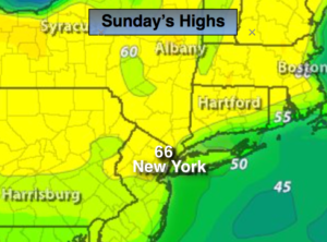
The 2nd half of the weekend will be a complete turnaround from Saturday’s grey damp skies. The sun will dominate today as a ridge of high pressure works in. It will be a beauty. Temperatures will be in the mid 60s. The average high for the date is 63º.
Monday will feature mainly cloudy skies. A storm will develop over the Southeast. High pressure will be off the New England coast. The combination of the two may result in a bit of light rain by Monday evening. A more widespread rain event is likely Tuesday and Tuesday night as the storm moves up and off the coast. It will raw.
Stay tuned.
Today:
Mostly sunny. Highs in the mid 60s. Winds becoming Southeast at 5-10mph.
Tonight:
Clear. Becoming mostly cloudy by sunrise. Lows in the upper 40s in the City, near 40º inland. Winds South at 5mph.
Monday:
Any early sun will give way to cloudy skies. Chance of light rain by late afternoon. Highs in the lower 60s.
Tuesday:
Rain likely. Breezy and cool. Highs in the lower to mid 50s.
Wednesday:
Early showers giving way to afternoon sun. Highs in the mid 60s.
Thursday:
Partly sunny. Much warmer. Highs around 80º.
Keep it here for a no nonsense, no hype forecast.