Synopsis:
Relief from the heat has arrived, but we’ll have to pay the price. A strong High will be over Southeastern Canada. This will result in a wind off the Atlantic. Readings will be much cooler today and Saturday. An upper level disturbance and a wind moist wind from the East will result in scattered showers today mainly from the City and to the South and West. Areas to the East could very well remain dry. Some of the rain over parts of NJ could be heavy. There will be dry times. It will be a drastic change from the sunshine and heat of the last few days.
On Saturday, the disturbance will have dissipated. Clouds will give way to some sun. A spot shower can’t be ruled out, but most of the day will be dry. Readings will be just below the average high of 81º.
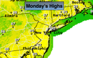
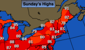
By Sunday into Labor Day Monday high pressure will re-establish itself over the East coast. A decent amount of sunshine is expected. It’ll become warmer and more humid.
The holiday weekend starts off damp and grey today but improves each and every day into Monday. Enjoy and stay safe!
Stay tuned.
Today:
Cloudy, much cooler and less humid. Scattered showers, Areas of heavy rain over parts of NJ in the morning. It most likely will remain dry East of the City. Highs in the mid 70s. East to Southeast winds at 8-12mph.
Tonight:
Mostly cloudy. A spot shower is possible. Lows in the 60s throughout. Light East wind.
Saturday:
Clouds should give way to some sun. An isolated shower is possible. Highs in the upper 70s.
Sunday:
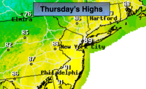
Partly sunny. Warmer and more humid. Highs in the lower to mid 80s.
Labor Day:
Hazy, warm and humid. Highs in the upper 80s.
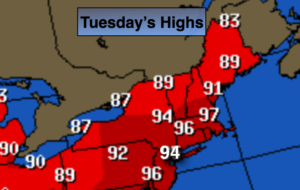
Tuesday:
Hazy, hot and humid. Highs around 90º.
Keep it here for a no nonsense, no hype forecast.