Synopsis:
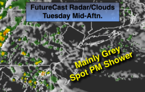
High pressure East of New England will produce a wind off the ocean today. This will result in mainly cloudy skies. An isolated shower is possible during the afternoon, but most areas will remain dry. Temperatures will be several degrees below the average high of 83º.
An area of low pressure and front will work in from the West tonight and Wednesday morning. The threat of showers will increase by tonight into the first half of Wednesday. A few thunderstorms are possible with local downpours. It’ll be more humid. This system will move off the coast later Wednesday with showers ending during the early afternoon and the sun will return later in the day.
High pressure will move in from the Midwest by late week. Sunny skies with much lower humidity is expected both Thursday and Friday. A couple of gems are on the way. Overnight readings will have that Fall feel with temperatures in the 50s inland.
Today:
Mostly Cloudy. Spotty showers are possible during the afternoon. Most areas will remain dry. More humid. Highs in the upper 70s. East to Southeast winds at 5-10mph.
Tonight:
Scattered showers with isolated storms. Locally heavy rain is possible. Muggy. Lows in the lower 70s in the City, the upper 60s inland. Southeast to Southwest winds at 5-10mph.
Wednesday:
Scattered showers through early afternoon. It’ll be humid to start. Increasing sunshine later in the day with lowering humidity. Highs in the lower 80s.
Thursday:
Mostly sunny, breezy and much less humid. Highs in the upper 70s to around 80º.
Friday:
Sunny. Highs around 80º.
Saturday:
Sunny. Highs in the lower 80s.
Keep it here for a no nonsense, no hype forecast.