Synopsis:
The high pressure system that gave us a beautiful weekend will slip off the coast today and strengthen. This will result in a return flow and bring up a hot bubble of air from the South and West. Readings today should reach the 90º mark and this very well could be the start of a late Summer heatwave. The humidity will also rise to uncomfortable levels. The combination of high temperatures and high humidity will cause the heat index to be 100º or higher, by Tuesday and Wednesday-a Heat Advisory has been posted for both days. A cool front will approach Thursday with spotty PM Storms. The heatwave will break by Friday.
Stay tuned.
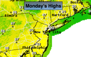
Today:
Hazy, hot and humid. Highs around 90º. Heat Index in the mid 90s. Southwest winds at 5-10mph.
Tonight:
Mostly clear, very warm and muggy. Lows in the mid to upper 70s in the City, around 70º inland. Light Southwest wind.
Tuesday:
Hazy, hot and humid. Highs in the lower to mid 90s. Heat index: 98º-104º.
Wednesday:
Hazy, hot and humid. Highs in the lower to mid 90s. Heat index: 98º-104º.
Thursday:
Hazy, hot and humid with spotty afternoon storms. Highs around 90º.
Friday:
Partly sunny, much cooler and less humid. Highs around 80º.
Keep it here for a no nonsense, no hype forecast.