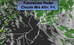
Synopsis:
Readings will rise above average today as winds turn to the South. Highs will flirt with 60º. A weak front will washout over the area resulting more clouds and possible spotty showers. The best chance of getting wet is to the North of the City.
The better half of the weekend will be Saturday. Under a mix of sun and clouds with a Southerly flow temperatures will soar well into the 60s, it’ll be cooler by the ocean. On Sunday a cool front will work through with scattered showers.
The beginning of the workweek looks bright and cool.
Keep it here for a no nonsense, no hype forecast.
Today:
Mostly cloudy, much milder. Spotty showers are possible. The best chance will be North of the City. Highs in the lower 60s. Cooler at the shore and over Long Island. South to Southwest winds at 5-10mph.
Tonight:
Spotty evening shower, otherwise mostly cloudy. Lows around 50º in the City, the 40s inland. Light Southeast wind.
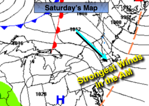
Saturday:
Partly sunny and warm. Highs around 70º. Much cooler over Long Island and coastal communities.
Sunday:
Mostly cloudy and mild. Scattered showers. Highs in the mid to upper 50s.
Monday:
Mostly sunny and cooler. Highs around 50º.
Tuesday:
Mostly sunny and cool. Highs around 50º.