Synopsis:
A large, strong high pressure system will settle over the East coast for the rest of the week. Sunny days will be with us through tomorrow. Temperatures will be slightly below average today but rise to above average by Friday as winds turn to the South. On Friday a weak front will washout over the area resulting only in some clouds.
The better half of the weekend will be Saturday. Under mainly sunny skies and a Southerly flow temperatures will soar well into the 60s. On Sunday a cool front will work through with scattered showers.
Keep it here for a no nonsense, no hype forecast.
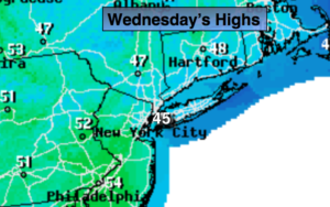
Today:
Sunny. Highs in the mid to upper 40s. Northeast to Southeast winds at 5mph.
Tonight:
Clear and chilly. Lows in the mid 30s in the City, the 20s inland. South to Southeast winds less than 5mph.
Thursday:
Sunny. Highs in the lower 50s.
Friday:
Clouds, some sun, much milder. Highs in the lower to mid 60s.
Saturday:
Mostly sunny and warm. Highs around 70º. Cooler over Long Island and coastal communities.
Sunday:
Mostly cloudy and mild. Scattered showers. Highs around 60º.