Synopsis:
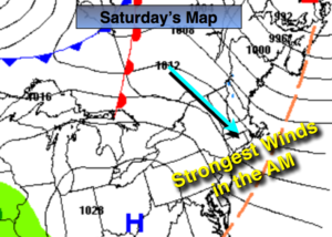
A strong storm over Southeastern Canada and a strong area of high pressure over the Ohio Valley will result in strong winds this morning. Winds could gust up to 45mph. The winds will begin to diminish some this afternoon.
Today will be chilly with readings about ten degrees lower than the average high for the date, which is in the lower 50s. Tomorrow will be the better half with much milder readings with winds relaxing. Both days will feature sunshine as high pressure works in from the West.
The beginning of the week looks tranquil as an area of low pressure slides to the South. Rain and snow will not affect the region with this system. A few showers are possible with the passage of a cool front Monday morning.
A large, strong high pressure system will move in for the majority of the week. Temperatures will be below average through midweek but then rise to above average late week.
Keep it here for a no nonsense, no hype forecast.
Today:
Partly sunny, windy and chilly. Highs in the lower to mid 40s. Northwest winds at 15-30mph with gusts up to 45mph in the morning. The winds will abate some during the afternoon.
Tonight:
Clear and cold. Lows in the mid 30s in the City, the 20s inland. West to Northwest winds diminishing to 5-10mph after midnight.
Sunday:
Mostly sunny and milder. A much better feel. Highs in the upper 50s.
Monday:
Mostly cloudy.. Chance of showers in the morning. Highs around 50º.
Tuesday:
Mostly sunny. Much cooler. Highs in the lower 40s.
Wednesday:
Sunny. Highs in the mid 40s.