Synopsis:
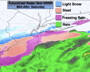
We’ll continue the grey theme for Presidents’ Day. Spotty freezing drizzle or drizzle will occur this morning as a weak impulse moves offshore. Much of the day should be precipitation free (2nd map above). Highs will be in the mid 30s. The arrival of steadier rain and freezing rain has been delayed by several hours. The precipitation now looks to move in between 9pm and midnight from Southwest to Northeast.
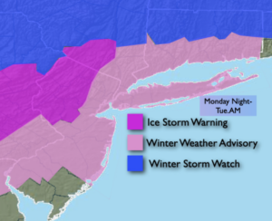
Tonight and Tuesday’s mornings event will be a quick but hard hitter. The storm now looks to take a track up the Piedmont to just East of NYC by Tuesday morning. The trend of warming this system up continues. This will result in temperatures getting above freezing along the coast and along the I-95 corridor and just to the North and West of that interstate. Any sleet or freezing rain will go over to plain rain-good news. The track here is key. Arctic high pressure will be to our North. Over the far inland ‘burbs significant icing is possible with freezing rain. An Ice Storm Warning has been posted for Northwestern NJ and Orange County NY. IF the temperature stays below 32º when the heaviest rain moves in overnight tonight, a serious icing situation will occur with possible downed tree limbs and power outages. My thinking continues that the areas to see these conditions are Sussex and Orange counties of NY. Just South of there in the Ice Storm Warning area, hopefully it will change to rain just in time for a bit of ice to just wet.
The storm will be moving rapidly and should be exiting our region by mid-Tuesday morning. The sun should quickly return and readings will get to around 40º-a heatwave!
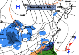
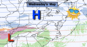
A well deserved brief break will greet us on Wednesday as a high pressure to the North delivers the sun and chill.
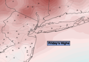
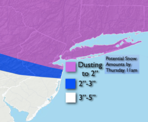
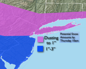
The next storm in this parade will be on Thursday. The potential is there for a thump of accumulating snow Thursday. Once again, the track of the storm will be very close to the region. This will result in snow changing to sleet, freezing rain and rain. This also looks to be a significant precipitation producer. All of this should end as a mix or rain on Friday morning with the sun returning and readings rising into the lower 40s!
Stay Tuned.
Keep it here for a no nonsense, no hype forecast.
Monday (Presidents’ Day):
Early morning drizzle or freezing drizzle, otherwise remaining cloudy. Highs in the mid 30s. Northeast winds at 5mph.
Tonight:
Freezing rain and rain developing (depending on location). Lows around freezing well North and West. The 30s in the NYC vicinity and nearby ‘burbs. Readings will rising to near 50º over Southern NJ and parts of Long Island by sunrise as the track of the inland riding storm brings up warm air from the South. Northeast to Southeast winds at 5-10mph.
Tuesday:
Morning freezing rain well inland, rain elsewhere. The sun will return by later in the morning through midday. Mild. Highs in the 30s to lower 40s.
Wednesday:
A mix of sun and clouds. Colder. Highs in the upper 20s to around freezing.
Thursday:
Snow. Potential quick hitting accumulation. Changing to a mix, first at the coast and to the South. Highs 30º-35º.
Friday:
Morning rain to sun. Mild. Highs in the upper 30s to lower 40s.