Synopsis:
We are turning the corner with the persistent cold. High pressure will take up residence over the Southeast this week. This will result in more pleasant temperatures today and Thursday.
As the high moves off the Southeast coast a Southwest wind should bring temperatures up to levels that will make most happy later this week and into Saturday. In fact, some areas may approach 80º by Saturday. A welcome change for many. It will be mainly dry through the beginning of the weekend.
Stay tuned.
Today:
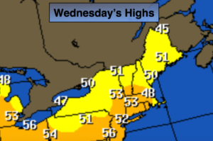
Mostly sunny. Milder. Highs in the lower to mid 50s. Winds becoming Southwest at 5-10mph.
Tonight:
Mostly cloudy. Not as cold as recent nights. Lows in the lower to mid 40s in the City, the 30s inland. Southwest winds at 5mph.
Thursday:
Partly sunny and mild. Highs in the lower 60s.
Friday:
Partly sunny. Much warmer. Highs in the lower to mid 70s.
Saturday:
Partly sunny. June-like. Highs well into the 70s to around 80º.
Sunday:
Mostly cloudy and much cooler. Areas of drizzle and spotty showers. Highs only in the lower to mid 50s.
Keep it here for a no nonsense, no hype forecast.