Synopsis:
Spring will finally make an appearance today as a warm front works through. Even though clouds and will dominate and spotty showers are possible temperatures will be seasonal for this time of the year-the lower 60s..
As the high moves off the Southeast coast a Southwest wind should bring temperatures up to levels that will make most happy Friday into Saturday. In fact, some areas may approach 80º by Saturday. A welcome change for many. It will be mainly dry through the beginning of the weekend.
The second half of the weekend will feature a back door cold front that will move South of the area. This will turn the wind off the colder Atlantic and keep the region much cooler than Saturday’s highs-it will be a shock. Scattered showers or areas of drizzle are likely on Sunday. A significant rain is possible on Monday as a deep Southern flow ahead of a cold front works in.
Stay tuned.
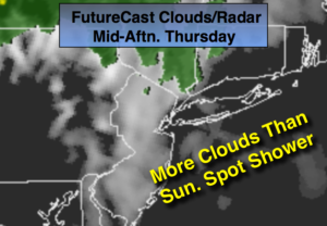
Today:
Mostly cloudy with spotty showers. More seasonal. Highs in the lower 60s. South wind at 10-15mph.
Tonight:
Partly cloudy. Much milder than recent nights. Lows in the mid 50s in the City, the mid to upper 40s inland. Southwest winds at 5mph.
Friday:
Partly sunny. Much warmer. Highs in the mid 70s.
Saturday:
Partly sunny. June-like. Highs in the 70s to around 80º over central NJ.
Sunday:
Mostly cloudy and much cooler. Areas of drizzle and spotty showers. Highs only around 50º.
Monday:
Rain, possibly heavy at times. Highs around 60º.
Keep it here for a no nonsense, no hype forecast.