Synopsis:.
Rapidly changing weather conditions will occur in the next 24 hours.
A cool front will push offshore during the morning with a spot shower. The majority of the day will be dry with the sun making an appearance from time to time. The cold air is lagging behind by about one hundred miles. For this reason Spring-like readings are expected. Highs will be around 60º.
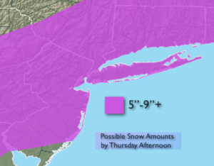
A dramatic change will take place tonight into Thursday. Cold air will rush into the region. At the same time an area of low pressure will move in from the Mid-Atlantic and off the NJ coast. The latest computer models are consistent from previous runs with the storm’s strength and precipitation. A mix of rain and snow will develop late tonight and turn to snow quickly by early Thursday morning. There is the potential for a plowable snow of 5″-9″+ (map above). The snow could come down heavy at times during the morning. This is a quick hitter with the brunt of the storm from 4am-11am. The snow will taper off mid-day to early afternoon. Please Stay Tuned.
Today:
A spot shower early morning shower, otherwise partly sunny. Balmy. Highs near 60º. Southwest to Northwest winds at 10-15mph.
Tonight:
Rain and snow developing after midnight. Changing to all snow. Lows freezing in the City, the 20’s inland. North wind at 10-20mph.
Thursday:
Snow, possibly heavy at times in the morning. The snow will taper off mid-day through early afternoon. Windy. Temperatures falling into the 20s.
Friday:
Sunny and cold with highs around 30º.
Saturday:
Mostly cloudy and seasonal. Highs around 40º.
Sunday:
Mostly cloudy. Scattered showers. Highs in the mid 40s.
Stay Tuned.
Keep it here for a no nonsense, no hype forecast.