Synopsis:.
Rapidly changing weather conditions will occur in the next 12 hours.
Temperatures reached into the 60s for record highs in some areas on Wednesday. Spring-like indeed.
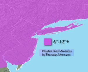
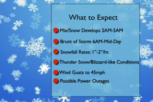
A dramatic change will take place tonight into Thursday. Cold air will rush into the region. At the same time an area of low pressure will move in from the Mid-Atlantic and off the NJ coast. The latest computer models are much more robust than previous runs with the storm’s strength and precipitation. A mix of rain and snow will develop late tonight and turn to snow quickly by early Thursday morning. It now looks like 6″-12″+ of snow is possible (map above). The snow will be heavy at times during the morning. Snowfall rates of 1″-2″/hr are expected with whiteout conditions and thunder snow possible. Winds will gust between 30-45mph. A Blizzard Warning is in effect for Suffolk County, Long Island. This region will experience the highest winds making for a blizzard. This is a quick hitter with the brunt of the storm from 6am-Mid-day. The snow will taper off mid-day to early afternoon. Please Stay Tuned.
Tonight:
Rain and snow developing between 2am-6am. Changing to all snow. Lows near freezing in the City, the 20’s inland. North wind at 10-20mph.
Thursday:
Snow, heavy at times in the morning. The snow will taper off mid-day through the afternoon. Windy. Temperatures falling into the 20s. North to Northwest wind at 15-35mph with gusts to 45mph.
Friday:
Sunny and cold with highs around 30º.
Saturday:
Mostly cloudy and seasonal. Highs around 40º.
Sunday:
Mostly cloudy. Scattered showers. Highs in the mid 40s.
Monday:
Partly sunny. Highs in the lower 40s.
Stay Tuned.
Keep it here for a no nonsense, no hype forecast.