Synopsis:.
High pressure over the Northern Plains will result in a persistent Northwesterly flow into Saturday. It’ll be much colder than recent days. Temperatures will actually drop below seasonal averages today & Saturday. The average high temperature is 39º.
The high will push off the coast on Sunday. At the same time a weak storm will move across the US/Canadian border and into Maine. A few flurries or sprinkles are possible later Super Sunday.
A complex storm system will move into the area Tuesday and Wednesday next week. A bit of wintry precipitation is possible Tuesday morning with a change to rain. Rain is likely the first half of Wednesday with mild readings. Not a snow lovers dream.
Today:
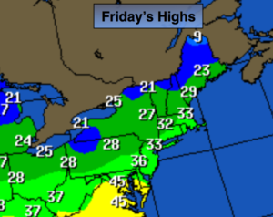
Sun and clouds, colder. Highs in the lower to mid 30s. West to Northwest winds at 10-20mph.
Tonight:
Becoming mostly clear. Cold. Lows in the mid 20s in the City, the teens inland. Northwest winds 10-20mph.
Saturday:
Mostly sunny. Highs around freezing.
Sunday:
Morning sun will give way to clouds. Afternoon flurries or sprinkles are possible. Highs around 40º.
Monday:
Mostly sunny. Highs around 40º.
Tuesday:
Morning wet snow, sleet or freezing rain will go over to rain. Highs around 40º.
Stay Tuned.
Keep it here for a no nonsense, no hype forecast.