Synopsis:
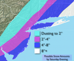
Periods of snow of varyring intensity will fall into the afternoon. There will be a sharp cutoff to the snow to the West. The map above is the possible accumulations expected by evening. The Western sections of each band will feature the lower amount within the range. If the storm jogs a bit to the West areas farther inland will see more snow. At this time Coastal NJ and Eastern Long Island will be in the jackpot zone for the highest amounts (snow amounts above). Well inland a bit of dim sunshine is possible with high clouds. The snow will end from Southwest to Northeast during the late afternoon and evening. Snow will most likely quit over Eastern sections by late evening.
The cold blast is the other top story for the weekend. Highs will be below freezing both days with lows in the teens.
Saturday:
Snow likely from I-95 corridor and to the East, mostly cloudy well inland. Highs in the mid 20s. North wind at 10-20mph.
Tonight:
Snow ends East, becoming mostly clear and frigid. Lows in the upper teens in the City, near 10º North and West wind chills near 0º. Northwest winds at 10-20mph.
Sunday:
Mostly sunny and cold. Highs in the mid to upper 20s.
Monday:
Sunny. Cold. Highs in the upper 20s.
Tuesday:
Sun will give way to clouds, mild. Highs in the mid 40s.
Wednesday:
Morning showers, afternoon sun. Mild. Highs around 50º.
Stay Tuned.
Keep it here for a no nonsense, no hype forecast.