Synopsis:
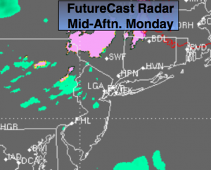
Spotty drizzle and areas of light rain will develop during the morning hours as a warm front moves toward the region. It should be cold enough well North and West for spotty freezing drizzle or light freezing rain (FutureCast radar above). Icy conditions may develop on untreated surfaces. During the afternoon all areas will be above freezing. A cool front will move through the region on Tuesday morning. Early rain will end by mid morning. The cold air is lacking behind the front. Temperatures on Tuesday will feel more like Spring.
A more significant cold front will move toward the area by Thursday morning. Some of the computer models want to develop a wave of low pressure close the the region. Rain will develop Thursday morning. It maybe cold enough for wet snow to be mix in, especially inland. It doesn’t look a big deal with accumulations, but well inland a minor amount is possible. Colder weather will move in to end the year.
Today:
Cloudy. Spotty drizzle or light rain. Inland spotty freezing drizzle or light freezing rain is possible. All areas will go over to liquid during the afternoon. Highs in the 40s. Northeast to Southeast wind at 5-10mph.
Tonight:
Periods of light rain or drizzle. Mild. Lows in the 40s. South to Southwest wind at 10-15mph.
Tuesday:
Morning rain will give way to sunny skies. Mild. Highs in the mid to upper 50s.
Wednesday:
Sunny with highs in the mid 40s.
Thursday:
Rain mixed with wet snow, especially inland. Highs in the lower 40s.
Friday:
Partly sunny. Colder. Highs in the upper 30s.
Stay Tuned.
Keep it here for a no nonsense, no hype forecast.