Synopsis:
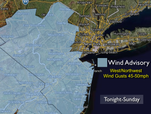
It’ll be the tale of two seasons this weekend. The warm bubble of high pressure moving off the coast will give us one more Spring-like day today. A powerful cold front will move through tonight and usher in the coldest air of the season on strong West Northwest winds; it’ll feel like Winter on Sunday. Snow showers are possible later tonight over the Northern suburbs. A Wind Advisory has been posted for areas to the West of the City for later tonight and Sunday (These advisories will most likely cover the City and areas to the East later today). Wind gusts of 45-50mph are quite possible. Temperatures on Sunday will be almost 20º colder than today. Factor in the wind and the wind chills will be in the 30s. A major shock to the body.
The chill will remain with us through the early week. The weather will cooperate for the big travel day Wednesday. At this time Thanksgiving looks damp. Showers are likely with readings around 50º.
Today:
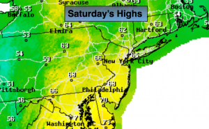
Mostly sunny and warm. Highs in the mid 60s. Cooler at the coast. Northwest wind at 5mph.
Tonight:
Mostly cloudy, windy and much colder. Scattered rain and snow showers. Lows near 40º in the City, the 30s inland. West Northwest wind increasing to 15-30mph with gusts to 50mph.
Sunday:
Mostly cloudy, windy and cold. A few flurries or sprinkles are possible. Highs in the mid 40s.
Monday:
Clouds and sun. Chilly and windy. Highs will be in the mid 40s. Wind chills in the 30s.
Tuesday:
Mostly sunny. Highs will be in the upper 40s.
Wednesday (Getaway Day):
Mostly sunny. Highs in the lower 50s.
Stay Tuned.
Keep it here for a no nonsense, no hype forecast.