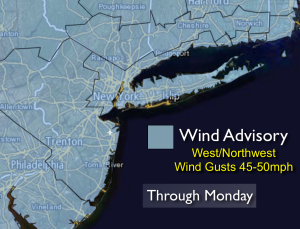
Synopsis:
The cold blast will stick around for a couple of days. Scattered snow showers inland today. A Wind Advisory is in effect through this afternoon. Wind gusts of 45-50mph are quite possible. An intensifying area of low pressure over New England combined with a strong high pressure over the Northern plains will create a strong pressure gradient which results in high winds. Factor in the wind and the wind chills will be in the 20s tonight 30s on Monday. A far cry from the 60’s of Saturday.
The weather will cooperate for the big travel day Wednesday. At this time Thanksgiving looks damp.
Today:
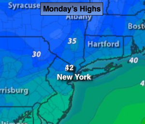
Clouds and sun with scattered snow showers, mainly inland. Chilly and windy. Highs will be in the lower 40s. Wind chills in the 30s. West wind at 15-30mph with gusts to 50mph.
Tonight:
Mostly cloudy, windy and cold. Lows near freezing in the City, the upper 20’s inland. West wind 15-30mph with gusts to 40mph.
Tuesday:
Mostly sunny, not as windy. Highs will be in the mid 40s.
Wednesday (Getaway Day):
Mostly sunny. Highs in the upper 40s.
Thanksgiving Day:
Chance of showers. Highs in the lower 50s.
Friday:
Partly sunny. Highs in the lower 50s.
Stay Tuned.
Keep it here for a no nonsense, no hype forecast.