Synopsis:
A warm stretch is on the way through Saturday. It will not feel like mid November as high pressure builds over the East coast with the lack of any cold air. In fact, today’s highs in the mid to upper 60s is the average temperature for early May! Saturday will be the last hoorah for the usual warmth. An energized trough will develop along the East coast by Sunday. This will most likely bring down some of the coldest air this season so far and possibly some snow showers.
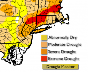
Even though parts of the tri-state area received some beneficial rain the last week which helped the dry conditions for those areas, many areas went almost rain-free. Conditions have now advanced to Extreme drought over the mid-hudson valley. Parts of Western NJ are border-line extreme as well. Rainfall deficits for the year range from six to fifteen inches. Reservoir levels are about 20% lower than the normal capacity of 75% for this time of the year. No major rainfall is expected for the next 5 days.
Today:
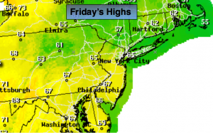
Sunny and warm. Highs in the mid to upper 60s. The record high is 73º. The average high is 53º. Northwest wind at 5mph.
Tonight:
Clear. Lows near 50º in the City, the 30s inland. Northest wind at 5 mph.
Saturday:
Partly sunny with readings in the mid 60s.
Sunday:
More clouds than sun, windy and much colder. Scattered rain and snow showers are possible. Highs will be in the mid to upper 40s.
Monday:
Partly sunny and chilly. Highs will be in the mid 40s. Wind chills will be in the 30s.
Tuesday:
Mostly sunny with below average temperatures . Highs will be in the mid 40s. Wind chills will be in the 30s.
Stay Tuned.
Keep it here for a no nonsense, no hype forecast.