Synopsis:
A mix of sun and clouds is expected for today. A warm Southwest wind will cause temperatures to soar into the lower 80s. It’ll cooler at the coast and over Long Island. An isolated shower is possible but much of the day will be dry.
A familiar forecast will be with us for the beginning to middle portion of the week. It’ll be mild to warm under a mix of clouds and sun. Spotty showers are possible just about anytime, but by no means will it be a washout as low pressure disturbances rapidly move through. The best chance of showers will be Wednesday with the passage of a cool front.
Thursday’s temperatures will return to more seasonal levels under mainly sunny skies.
Stay tuned.
Keep it here for a no nonsense, no hype forecast
Today:
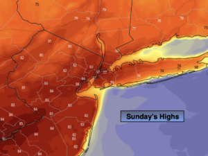
Partly sunny. Much Warmer. An isolated shower possible (mainly North). Highs in the lower 80s. Cooler at the coast.
Tonight:
Mostly cloudy. Lows around 60º in the City, the 50s inland. Light Winds.
Monday:
Sun and clouds. Spot shower. Mild. Highs in the mid 70s.
Tuesday:
Partly sunny. Spot shower. Much Warmer. Highs in the lower 80s.
Wednesday:
Clouds, some sun. Scattered showers. Highs in the mid 70s.
Thursday:
Mostly sunny. Seasonal. Highs in the upper 60s.