Synopsis:
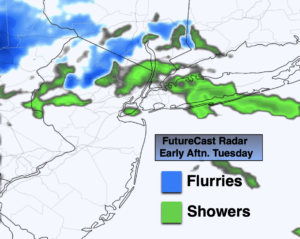
It will get progressively colder through midweek as a dominant Northwesterly flow prevails from Canada. The wind will add a bite. Readings by Wednesday will be at least ten degrees below the average high of 54º. A mix of sun and clouds is expected today with spotty showers. Flurries will fly over the Northwestern ‘burbs. Wednesday will be brighter but cold.
A slow rebound in temperatures will begin on Thursday as high pressure slips off the coast and a Southwest wind develops. The sun will continue to dominate. By Friday readings will jump ten degrees with a milder push of air.
The weekend at this time looks bright and sunny.
Stay Tuned.
Keep it here for a no nonsense, no hype forecast.
Today:
Clouds and sun breezy and chilly. Spotty showers, flurries inland. Highs in the upper 40s, lower to mid 40s inland. West to Northwest winds increasing to 15-25mph during the afternoon.
Tonight:
Mostly clear and cold. Lows around 30º in urban areas, the 20s inland. Northwest winds at 15-25mph. Wind chill in the 20s.
Wednesday:
Sunny, breezy and cold. Highs around 40º, the 30s inland. Wind chills near freezing.
Thursday:
Sunny. Chilly. Highs in the upper 40s.
Friday:
Sunny. Milder. Highs in the upper 50s.
Saturday:
Sunny. Mild. Highs around 60º.