Synopsis:
Tonight will be the coldest night of the season so far. A Freeze Waring has been posted for the City (all other areas have had a previous freeze). Strong high pressure which originated in the North is responsible for the chill.
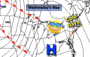
Wednesday will be cold, despite wall to wall sunshine. Readings will be almost fifteen degrees below the average high of 54º.
A slow rebound in temperatures will begin on Thursday as high pressure slips off the coast and a Southwest wind develops. The sun will continue to dominate. By Friday readings will jump ten degrees with a milder push of air.
The weekend at this time looks bright, sunny and mild as another high pressure system influences our region.
Stay Tuned.
Keep it here for a no nonsense, no hype forecast.
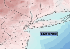
Tonight:
Mostly clear and cold. Lows around 30º in urban areas, the 20s inland. Northwest winds at 15-25mph. Wind chill in the 20s.
Wednesday:
Sunny, breezy and cold. Highs around 40º, the 30s inland. Wind chills near freezing. Northwest winds at 10-20mph.
Thursday:
Sunny. Chilly. Highs in the upper 40s.
Friday:
Sunny. Milder. Highs around 60º.
Saturday:
Sunny. Mild. Highs around 60º.
Sunday:
Mostly sunny. Mild. Highs in the upper 50s.