Synopsis:
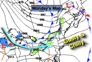
Monday through Wednesday will be dry but getting progressively colder as a dominant Northwesterly flow prevails from Canada. The wind will add a bite to the chill. Readings by midweek will be at least ten degrees below the average high of 54º. A mix of sun and clouds is expected. A few flurries may even fly over the Northwestern ‘burbs on Tuesday.
A slow rebound in temperatures will begin on Thursday as high pressure slips off the coast and a Southwest wind develops. The sun will continue to dominate. By Friday readings will be well above average.
Stay Tuned.
Keep it here for a no nonsense, no hype forecast.
Monday:
Mostly sunny and breezy. Highs in the lower 50s. West winds at 10-20mph with gusts to 30mph.
Tonight:
Mostly clear and cold. Lows in the 30s throughout. West winds diminishing to 8-12mph.
Tuesday:
Partly sunny, breezy and chilly. Chance of a few flurries inland. Highs in the upper 40s.
Wednesday:
Mostly sunny. Cold. Highs around 40º.
Thursday:
Sunny. Chilly. Highs in the upper 40s.
Friday:
Sunny. Milder. Highs in the upper 50s.