Synopsis:
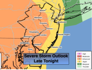
A storm over the Ohio valley and ride North into Northern New England the next 24 hours. There will be areas of fog, spotty showers and drizzle through early tonight. A period of heavy rain and possible severe thunderstorms are likely late tonight and very early Monday morning as the storm moves well to our Northwest and drags a cold front through. Some of the storms may contain winds in excess of 58mph and torrential rain. The 1st map above depicts an enhanced risk of severe storms over Western section of the tri-state area. Farther to the East a slight risk of severe storms is possible, which includes the NYC vicinity.
After the rain and storms end early Monday morning it will become partly sunny and windy. Winds could gust up to 45mph out of the Northwest.
Tuesday will be the pick day of the week with mostly sunny skies as high pressure dominates over the Mid-Atlantic. Another high will slip off the New England coast midweek and a stationary front will be in the vicinity. This will result in more clouds on Wednesday with the possibility of some showers or patchy drizzle Thursday. Readings near the seasonal average of 60º. By Friday another front will be approaching with balmy conditions and possible showers later in the day.
Keep it here for a no nonsense, no hype forecast.
Stay tuned.
Tonight:
Cloudy with areas of fog, drizzle and showers. A period of rain and thunderstorms is likely late tonight. Lows in the 50s to around 60º throughout. South to Southwest winds increasing to 15-25mph with higher gusts.
Monday:
Rain and thunderstorms ending during the early morning, becoming partly sunny and windy. Highs in the lower 60s. Northwest winds at 15-30mph with gusts to 45mph.
Tuesday:
Partly sunny. Highs in the lower 60s.
Wednesday:
Sun and clouds. Highs around 60º.
Thursday:
Mostly cloudy. Spotty showers possible. Highs around 60º.
Friday:
Mostly cloudy and warm. Showers possible by afternoon. Highs near 70º.