Synopsis:
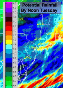
A low will move up the Eastern Seaboard tonight into Tuesday Morning resulting in quick shot of steady rain starting later this evening and continuing into Tuesday morning. The rain will end rapidly during the morning hours from West to East. On average an inch of rain is expected (1st map above). The sun will return soon after the rain ends.
Wednesday will be windy and cold with readings only in the 30s to around 40º-a Winter feel for sure. The average high temperature is 55º.
A second storm will affect the area Thursday afternoon into Friday. The models develop a low over the Southeast and move it up the coast. The latest computer guidance has cold high pressure being more of an influence to our North. With this setup, the potential is now there for wet snow to mix in with the rain inland from Thursday afternoon into Friday morning. No accumulation is expected at this time. Rain will fall along the coast. Could Winter be that far off?
You know where to find a no hype, no nonsense forecast.
Stay tuned.
Tonight:
Rain developing by late evening. Lows in the mid 40s in the City, the 30s inland. South to East winds at 5-10mph.
Tuesday:
Morning rain. The rain will end from West to East by mid to late morning. A mix of sun and clouds is expected once the rain ends. Highs in the lower to mid 50s. East to Northwest winds at 10-20mph.
Wednesday:
Mostly sunny, breezy and cold. Highs only in the 30s to around 40º.
Thursday:
Morning sun, afternoon clouds. Rain will move in later in the day. A mix of wet snow and rain is likely inland. Chilly. Highs in the lower 40s in the City, the 30s inland.
Friday:
Morning rain, a mix possible well inland. The sun may return for a time during the afternoon. Highs in the upper 40s.
Saturday:
Partly sunny and chilly. Highs in the upper 40s.
Keep it here for a no nonsense, no hype forecast.