Synopsis:
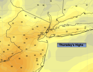
Cooler air will move in for Thursday as high pressure over Eastern Canada say hello for a day. Skies will be mainly sunny. Temperatures will be seasonal- in the mid 60s.
Friday will feature early morning showers with a warm front pushing North. Once the front goes by skies will become partly sunny and it’ll become warm and breezy. A cool front will approach toward evening with showers.
This cool front will be significant as it’s bringing down the coldest air of the season with it. Saturday’s highs will remain in the 50s under partly sunny skies. Strong winds gusts from the North up to 40mph is expected. Making the 50s feel like the 40s during the afternoon.
It’ll be more tranquil on Sunday with strong high pressure over the area. Sunny, cool conditions are expected.
Monday will be bright and cool with the high moving off the coast.
Stay tuned.
Keep it here for a no nonsense, no hype forecast…
Tonight:
Mostly clear. Lows in the mid 50s in the City, the upper 40s and 50s elsewhere. North winds at 8-12mph.
Thursday:
Mostly sunny. Much cooler. Highs in the mid 60s. Northeast to East winds at 5-10mph.
Friday:
Early morning showers, otherwise a mix of sun and clouds. Breezy and warm. Late day or evening showers. Highs in the lower to mid 70s.
Saturday:
Mostly sunny, windy and much colder. Highs only in the lower to mid 50s.
Sunday:
Sunny and cool. Highs in the upper 50s.
Monday:
Sunny. Highs in the lower 60s.