Synopsis:
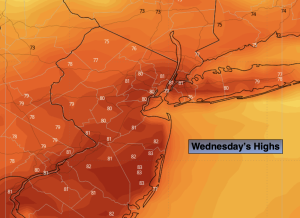
A warm bubble of air will be over the region today ahead of an approaching cold front. Under a mix of sun and clouds readings will flirt with 80º more typical of mid June than mid October.
Cooler air will move in for Thursday as high pressure over Eastern Canada say hello for a day. Skies will be mainly sunny. Temperatures will be seasonal- in the mid 60s.
Friday will feature a cool front moving through during the afternoon. A mix of sun and clouds are expected with showers possible from the mid-afternoon hours to early evening. Mild temperatures are expected. Winds will be gusty.
This cool front will be significant as it’s bringing down the coldest air of the season with it. Saturday’s highs will remain in the 50s under partly sunny skies. Strong winds gusts from the North up to 40mph is expected. Making the 50s feel like the 40s during the afternoon.
It’ll be more tranquil on Sunday with strong high pressure over the area. Sunny, cool conditions are expected.
Stay tuned.
Keep it here for a no nonsense, no hype forecast…
Wednesday:
Partly sunny. Warm. Highs in the mid 70s to around 80º. West winds at 5-10mph.
Tonight:
Mostly clear. Lows in the mid 50s in the City, the upper 40s and 50s elsewhere. North winds at 8-12mph.
Thursday:
Mostly sunny. Much cooler. Highs in the mid 60s.
Friday:
Sun and clouds. Windy and mild. Passing afternoon showers. Highs in the mid 70s.
Saturday:
Mostly sunny, windy and much colder. Highs only in the lower to mid 50s.
Sunday:
Sunny and cool. Highs around 60º.