Synopsis:
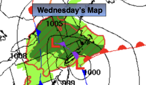
Low pressure over Long Island today will move very little. Rain will fall North and East of the City where a Flood Watch is in effect. To the South and West of the City a mix of sun and clouds is expected. A few showers may wrap around the low later today and affect the area. Highs will be below the average highs of the mid 80s.
Thursday will feature partly sunny skies with just the chance of a few showers. The low will move slowly off the New England coast.
On Friday and Saturday the sun will dominate as the system finally moves far enough offshore. Temperatures will be tolerable.
A moist Southerly flow will develop on Sunday. A mix of sun and clouds is expected. A few showers are possible. Both weekend days temperatures will be just below average.
Stay tuned.
Keep it here for a no nonsense, no hype forecast….
Wednesday:
Sun and clouds from the City South and West with a chance of afternoon scattered showers.. Areas of rain North and East of the City. Highs in the upper 70s. North to Northwest winds at 8-12mph.
Tonight:
Mostly cloudy. A few showers possible. Lows in the 60s throughout. Northwest winds at 8-12mph.
Thursday:
Sun and clouds. Spotty showers possible. Highs in the upper 70s.
Friday:
Mostly sunny. Highs in the lower 80s.
Saturday:
Partly sunny. Highs in the mid 80s.
Sunday:
Sun and clouds. Few afternoon showers possible. Highs in the lower 80s.