Synopsis:
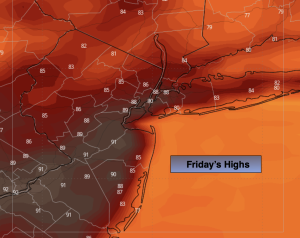
A mix of sun and clouds is expected today. It’ll be warm. Weak high pressure to the North will influence our weather.
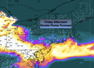
Smoke from the Canadian wildfires won’t be as intense today. There will be more smoke to the South of the City and not much of any to the North (smoke plume forecast above). Those with respiratory issues should remain indoors as much as possible.
On Saturday weak low pressure will be to our South. This system will be responsible for scattered showers and storms. Some of the rainfall could be heavy.
Sunday will be the better half of the weekend. Partly sunny skies and seasonal temperatures are expected.
The week will start off bright and warm as high pressure moves overhead.
A warm front will move toward the area on Tuesday. A mix of sun and clouds is expected with the chance of afternoon storms.
Stay tuned.
Keep it here for a no nonsense, no hype forecast…
Friday:
Partly sunny. Areas of smoke, mainly to the South of the City. Highs in the mid to upper 80s. Light and variable winds.
Tonight:
Partly cloudy. Lows in the lower 70s in the City, the 60s inland. South winds at 5mph.
Saturday:
Mostly cloudy. Humid. Chance of showers and storms. Locally heavy rain. Highs in the lower 80s.
Sunday:
Mostly sunny. Highs in the mid 80s.
Monday:
Sunny. Highs in the mid 80s.
Tuesday:
Partly sunny. Chance of afternoon storms. Highs in the mid 80s.