Synopsis:
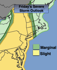
The heat will continue through today as a bubble of hot air remains over the region. The heat index will hover around 100º. The threat for late day and evening storms are possible with a weak cool front. A few of the storms may turn severe. Keep an eye to the sky for threatening weather between 3pm-9pm.
The weekend will be very warm but dry under a mix of sun and clouds. The humidity will lower. A few storms are possible late Sunday with an approaching cool front. The humidity will also be higher on Sunday.
Monday and Tuesday will be much more comfortable with lower temperatures and humidity. Skies will be partly sunny.
Stay tuned.
Keep it here for a no nonsense, no hype forecast…
Friday:
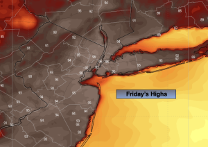
Partly sunny, hot and humid. Spotty PM storm. Highs in the lower to mid 90s. Heat index around 100º. West winds at 8-15mph.
Tonight:
Spotty evening shower or storm, otherwise partly cloudy. Becoming less humid. Lows around 70º in the City, the 60s inland. Light North wind.
Saturday:
Mostly sunny. Less humid. Highs around 90º.
Sunday:
Partly sunny. Late day or evening storm possible. Highs around 90º.
Monday:
Mostly sunny. Cooler and less humid. Highs in the lower 80s.
Tuesday:
Partly sunny. Highs in the lower 80s.