Synopsis:
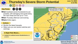
The heat will return today and Friday with highs both days in the lower to mid 90s as a bubble of hot air engulfs the region. The heat index will hover around 100º both days. A spot PM storm is possible Thursday and Friday. A few of the storms may turn severe. Keep an eye to the sky for threatening weather.
The weekend will be very warm but dry under a mix of sun and clouds. The humidity should be a tad lower than late week. A few storms are possible late Sunday with an approaching cool front.
Relief will arrive on Monday with lower temperatures and humidity. Skies will be partly sunny.
Stay tuned.
Keep it here for a no nonsense, no hype forecast…
Thursday:
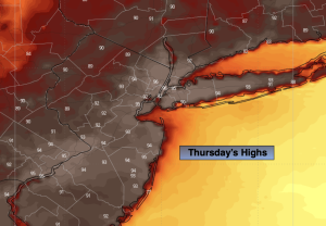
Hazy, hot and humid. Spotty PM storm. Highs in the lower to mid 90s. Heat index around 100º. West winds at 8-12mph.
Tonight:
Spotty evening shower or storm, otherwise partly cloudy and muggy. Lows in the mid 70s in the City, the 60s inland. Light West wind.
Friday:
Partly sunny, hot and humid. Spotty PM storm. Highs in the lower to mid 90s. Heat index around 100º.
Saturday:
Mostly sunny. Less humid. Highs around 90º.
Sunday:
Partly sunny. Late day or evening storm possible. Highs around 90º.
Monday:
Mostly sunny. Cooler and less humid. Highs in the lower 80s.