Synopsis:
A heatwave is on the way for many areas away from the coast. A heatwave consists of three consecutive days at 90º or above. A Bermuda High has established itself and will result in hot conditions through midweek. Mainly sunny skies are expected into Wednesday.
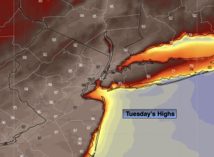
The record high for Central Park for Tuesday is 99º set in 1962. I think this record will continue to hold. Newark’s record is 98º also set in 1962. This record maybe tied or broken.
The next change will come with a cool front later Wednesday afternoon. Scattered afternoon storms are possible. This will break the hot spell.
Relief will arrive Thursday and Friday as cool Canadian high pressure influences our area.
Looking ahead, the Memorial Day Weekend looks unsettled. The potential for showers has increased significantly for Saturday. Sunday the shower threat remains but it shouldn’t be a washout. At this time Memorial Day looks like the best of the bunch with a mix of sun and clouds. Temperatures will be below the average high of the lower to mid 70s for the three day weekend.
Stay tuned.
Keep it here for a no nonsense, no hype forecast…
Tonight:
Clear. Very warm. Lows in the lower 70s in the City, the 60s inland. South winds at 5mph.
Tuesday:
Mostly sunny. Hot. Highs 93º-99º. Cooler along the immediate coast. Southwest winds at 10-20mph with gusts to 25mph.
Wednesday:
Hazy and hot. Scattered afternoon storms. Highs in the lower to mid 90s.
Thursday:
Mostly sunny. Much cooler. Highs in the lower 70s.
Friday:
Partly sunny Highs in the upper 60s.
Saturday:
Showers likely. Chilly. Highs only around 60º.