Synopsis:
A heatwave is on the way for many areas away from the coast. A heatwave consists of three consecutive days at 90º or above. A Bermuda High has established itself and will result in hot conditions through midweek. Mainly sunny skies are expected into Wednesday.
The next change will come with a cool front later Wednesday afternoon. Scattered afternoon storms are possible. This will break the hot spell.
Relief will arrive Thursday and Friday as cool Canadian high pressure influences our area.
Looking ahead, the Memorial Day Weekend looks unsettled. The potential for showers has increased significantly for Saturday and Sunday.
Stay tuned.
Keep it here for a no nonsense, no hype forecast…
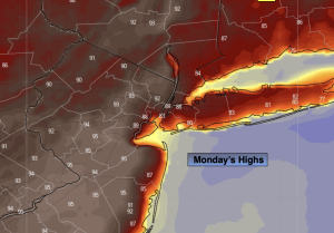
Monday:
Sunny. Hot. Highs in the lower to mid 90s along the urban corridor. Much cooler farther East and at the coast. South winds at 8-12mph.
Tonight:
Clear. Very warm. Lows in the lower 70s in the City, the 60s inland. South winds at 5mph.
Tuesday:
Mostly sunny. Hot. Highs in the lower to mid 90s.
Wednesday:
Hazy and hot. Scattered afternoon storms. Highs in the lower to mid 90s.
Thursday:
Mostly sunny. Much cooler. Highs in the lower to mid 70s.
Friday:
Partly sunny Highs around 70º.