Synopsis:
Today will be the best day of the next five. Warm temperatures and abundant sun is expected. Highs will be about ten degrees above the average high of the mid 60s as high pressure noses in from Eastern Canada.
Seasonal conditions are expected for Friday under a mix of sun and clouds.
Low pressure will affect the region on Saturday with rain and cool readings. Any rain will be beneficial as we are in a deficit. The low will be off the coast Sunday. Morning clouds and light rain should give way to some afternoon sun. Temperatures both days will be below average.
The sun will return on Monday along with pleasant temperatures.
Stay tuned.
Keep it here for a no nonsense, no hype forecast…
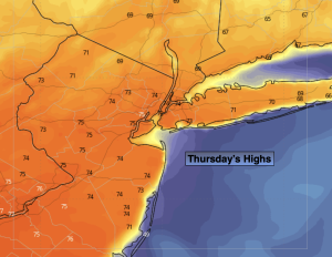
Thursday:
Mostly sunny. Warmer. Highs in the lower to mid 70s. Northwest winds at 10-15mph.
Tonight:
Mostly clear. Lows in the lower 50s in the City, the 40s inland. North winds at 5-10mph.
Friday:
Partly sunny. Highs in the lower to mid 60s.
Saturday:
Rain likely. Cooler. Highs around 50º.
Sunday:
Mostly cloudy. AM light rain. Some late sun possible. Highs in the mid to upper 50s.
Monday:
Sunny. Highs in the lower 60s.