Synopsis:
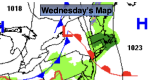
Weak low pressure will be over the Northeast today. This will result in scattered showers until about midday. Temperatures will still be much cooler than the average high of the lower to mid 60s.
Milder conditions are expected Thursday and Friday as high pressure dominates. Partly sunny skies are expected.
Low pressure will affect the region on Saturday with showers and cool readings. The low will be off the coast Sunday. Morning clouds and spotty showers should give way to some afternoon sun. Temperatures both days will be below average.
Stay tuned.
Keep it here for a no nonsense, no hype forecast…
Wednesday:
Mostly cloudy. Scattered showers through midday. Highs in the mid 50s. Southeast to North winds at 5-10mph.
Tonight:
Partly cloudy. Lows in the upper 40s in the City, the upper 30s to lower 40s inland. North winds at 5 mph.
Thursday:
Mostly sunny. Milder. Highs around 70º.
Friday:
Partly sunny. Highs in the mid 60s.
Saturday:
Showers likely. Cooler. Highs around 50º.
Sunday:
Mostly cloudy. Spot AM shower. Highs in the upper 50s.