Synopsis:
Today through Friday will be unsettled as a warm front approaches today followed by a cool front passage Friday. On and off showers are likely during this timeframe. There will be long periods of dry time. The greatest chance of steadier and heavier rain will be Thursday night into Friday morning with the approaching cool front. It’ll be windy during this period as well. Readings will be slightly above the average high of 60º.
Behind the low on Saturday skies will be partly cloudy. It’ll be breezy and cooler. It’ll warm up nicely on Sunday as a Southwesterly flow takes hold.
Stay tuned.
Keep it here for a no nonsense, no hype forecast.
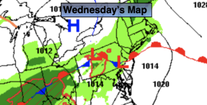
Wednesday:
Mostly cloudy. Cooler. Spotty showers. Highs in the lower 60s. East winds at 5-10mph.
Tonight:
Mostly cloudy. Spotty showers. Lows in the upper 40s to lower 50s. East winds less than 5mph.
Thursday:
Mostly cloudy. Scattered showers. Breezy. Highs in the lower 60s.
Friday:
Morning rain, otherwise mostly cloudy with scattered afternoon showers. Breezy. Highs in the mid 60s.
Saturday:
Partly cloudy, breezy and cooler. Highs in the upper 50s.
Sunday:
Partly sunny. Milder. Highs in the upper 60s.