Synopsis:
Today will feel like a day out of late May. A warm Southwest flow will dominate around high pressure situated off the Southeast coast. Readings will pop into the 70s! It will be much cooler along the immediate coast and Long Island.
Wednesday through Friday will be unsettled as a warm front approaches Wednesday followed by a cool front passage Friday. On and off showers are likely during this timeframe. The greatest chance of steadier and heavier rain will be Thursday night into Friday morning with the approaching cool front.
Behind the low on Saturday skies will be partly cloudy. It’ll be breezy and cooler.
Stay tuned.
Keep it here for a no nonsense, no hype forecast.
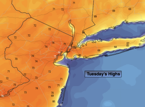
Tuesday:
Partly sunny. Warmer. Highs in the lower to mid 70s. Cooler at the coast and Long Island. North to Southeast winds 5-10mph.
Tonight:
Mostly cloudy. Lows in the upper 40s to lower 50s. Southeast to East winds 5mph.
Wednesday:
Mostly cloudy. Scattered showers. Highs in the mid to upper 50s.
Thursday:
Mostly cloudy. Scattered showers. Highs in the lower 60s.
Friday:
Morning rain, otherwise mostly cloudy with scattered showers. Highs in the mid 60s.
Saturday:
Partly cloudy, breezy and cooler. Highs in the upper 50s.