Synopsis:
Sunday will be the better half of the weekend with high pressure moving in. Readings will be more seasonable in the mid to upper 50s under a mix of sun and clouds.
High pressure will dominate on Monday. This should provide decent viewing conditions for the solar eclipse. Mostly sunny skies are forecast with mild readings.
The mild trend will continue Tuesday as readings soar to more than ten degrees above the average high of the upper 50s.
Wednesday through Friday will be unsettled as a warm front approaches Wednesday followed by a cool front passage Friday. On and off showers are likely during this timeframe.
Stay tuned.
Keep it here for a no nonsense, no hype forecast.
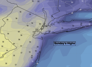
Sunday:
Sun and clouds. Milder. Highs in the upper 50s. North winds at 8-12mph.
Tonight:
Clear. Lows in the lower 40s in the City, the 30s elsewhere. Light Northwest winds.
Monday:
Mostly sunny. Milder. Highs in the lower to mid 60s.
Tuesday:
Partly sunny. Warmer. Highs in the lower 70s.
Wednesday:
Mostly cloudy. Scattered showers. Highs in the mid to upper 50s.
Thursday:
Mostly cloudy. Scattered showers. Highs in the lower 60s.