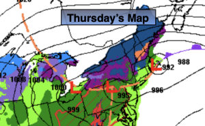
Synopsis:
The storm that gave the region a few days of heavy rain will move from Eastern Long Island to East of Boston today. There will be a few hours of sun in some areas especially this morning, but as the upper low moves in from the West clouds will roll back in. Scattered rain and possibly snow showers inland will move in later today and tonight.
Friday and Saturday the storm will be East of New England and weakening. We’ll be left with upper low pressure over the region. This will cause the atmosphere to be unstable. A spotty shower is possible Friday afternoon under a mix of sun and clouds. A gusty Northwest breeze will create a nip in the air. We’ll definitely be experiencing Spring’s chilly side through the period.
Sunday will be the better half of the weekend with high pressure moving in. Readings will be more seasonable in the mid to upper 50s under abundant sunshine.
High pressure will dominate on Monday. This should provide decent viewing conditions for the solar eclipse. Mostly sunny skies are forecast with mild readings.
Stay tuned.
Keep it here for a no nonsense, no hype forecast.
Thursday:
Mostly cloudy (some am sun in spots). Scattered rain and snow showers (inland) later today. Highs in the mid to upper 40s. Northwest winds at 8-15mph.
Tonight:
Mostly cloudy. Scattered rain and snow showers. Lows in the 30s throughout. Northwest winds at 8-12mph.
Friday:
Clouds and sun. Breezy. Spotty afternoon shower. Highs around 50º.
Saturday:
Clouds and sun. Breezy. Highs in the lower 50s.
Sunday:
Mostly sunny. Milder. Highs in the mid to upper 50s.
Monday:
Mostly sunny. Highs in the lower 60s.