Synopsis:
The wind will be the story through today as low pressure over Maine and high pressure over the South will result in strong winds. Today will feature a mix of sun and clouds. Winds could gusts in excess of 50mph. Readings will be seasonable in the upper 40s but the wind will definitely add a bite. The winds will slowly abate tonight.
Tuesday through Thursday will be more tranquil with milder readings as high pressure takes control. There will definitely be a Spring feel! Readings will feel like May by Thursday.
A weak front will push into the area on Friday with more clouds and possibly a few light showers, but it will still be mild!
Stay tuned.
Keep it here for a no nonsense, no hype forecast..
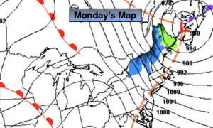
Monday:
Partly sunny, windy and chilly. Highs in the upper 40s. West to Northwest winds at 15-30mph with gusts to 50mph.
Tonight:
Mostly clear. Winds will slowly diminish. Lows in the upper 30s along the urban corridor near 30º inland. West to Northwest winds to 15-30mph, diminishing to 10-15mph.
Tuesday:
Sunny. Milder. Highs near 60º.
Wednesday:
Sunny. Mild. Highs in the mid 60s.
Thursday:
Partly sunny. Warm. Highs near 70º.
Friday:
Mostly cloudy. Scattered showers possible. Mild. Highs in the mid 60s.