Synopsis:
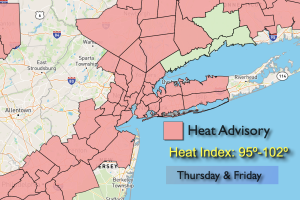
It’ll be another scorcher today. Readings will reach the highest temperatures recorded all Summer long at 93º. The temperature hit 93º yesterday at Central Park. A similar reading is expected today. Hazy sunshine and humid conditions are in the forecast.
The bubble of heat over our region will break down on Friday. This should keep temperatures below the 90º mark. At the same time a weakening front will approach from the West. The threat of late day and evening storms are in the forecast although the latest guidance has most areas dry. A higher threat of showers and storms are likely on Saturday and Sunday as the disturbance stalls over the region and weakens. This weekend will not be a washout. There will be more clouds than sun but an all day rain is not expected. It’ll be humid through the weekend as a Southerly flow continues.
Stay tuned.
Keep it here for a no nonsense, no hype forecast.
Thursday:
Hazy, hot and humid. Highs in the lower to mid 90s. Cooler at the coast. West to South winds at 5-10mph.
Tonight:
Partly cloudy. An isolated shower or storm possible. Most areas will remain dry. Lows in the mid 70s in the City, the 60s inland. Light South winds.
Friday:
Partly sunny. Not as hot. Humid. Late day or evening shower or storm possible. Highs in the mid 80s.
Saturday:
Mostly cloudy. Scattered showers and storms possible. Highs in the lower 80s.
Sunday:
Mostly cloudy. Scattered showers. Highs around 80º.
Monday:
Mostly cloudy. Scattered showers. Highs around 80º.