Synopsis:
A cool front will be responsible for scattered showers early this morning. It will be more of a humidity buster with levels coming way down. A mix of sun and clouds is expected and it’ll be breezy- a refreshing change for August.
An upper low over Northern New England of Saturday will result in a dry Northwest flow and much more comfortable conditions under a mix of sun and clouds. It’ll be cooler with very low humidity levels. A great feel for sure! Abundant sunshine is expected for Sunday with warming temperatures as high pressure builds over the region. Back to Summer.
Monday will be hazy, hot and humid around the Western Atlantic high.
A cool front will swing thorough the region Monday night. Tuesday will be another gem (like Saturday) with readings and humidity at comfortable levels.
Stay tuned.
Keep it here for a no nonsense, no hype forecast.
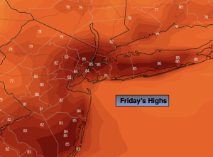
Friday:
Morning scattered showers. Sun and clouds. Breezy. Highs in the lower to mid 80s. West to Northwest winds at 10-20mph.
Tonight:
Clear. Cooler than recent nights. Lows in the lower to mid 60s in the City, the 50s inland. West to Northwest winds at 8-12mph.
Saturday:
Partly sunny. Highs in the upper 70s.
Sunday:
Sunny. Warmer. Highs in the upper 80s.
Monday:
Hazy, hot and humid. Highs around 90º.
Tuesday:
Sunny, cooler with lower humidity. Highs around 80º.