Synopsis:
Weather systems will be weak today through Thursday night. This will result in a mix of clouds and sun. Morning showers will move offshore today and another round of showers with a lingering warm front is possible Thursday evening. Much of the next two days will be dry.
A cool front will work through the region Friday morning. Clouds and an isolated shower will give way to partly sunny skies.
The weekend looks stellar with abundant sunshine and warming temperatures as high pressure builds over the region.
Stay tuned.
Keep it here for a no nonsense, no hype forecast.
Wednesday:
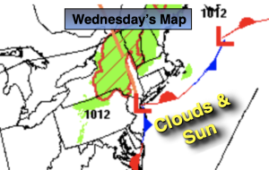
Early morning showers East, otherwise a mix of clouds and sun. Highs around 80º. East winds at 5-10mph.
Tonight:
Partly cloudy. Lows around 70º in the City, the 60s inland. Southeast winds at 5mph.
Thursday:
Partly sunny. Chance of late day showers and isolated storms. Highs in the lower 80s.
Friday:
Partly sunny. Highs in the lower 80s.
Saturday:
Mostly sunny. Highs in the lower 80s.
Sunday:
Sunny. Warmer. Highs in the upper 80s.