Synopsis:
Canadian air will work in from New England today. This will result in much cooler readings (a far cry from Friday’s 90º) under a mix of clouds and sun.
Sunday through Wednesday’s conditions will be dominated a consolidating upper level low over the Northeast. The main result of this system will be tolerable temperatures. Average highs are in the mid 70s. After Sunday’s cool readings, temperatures will be near average through midweek. Sun and clouds are expected through this timeframe.
Stay tuned.
Keep it here for a no nonsense, no hype forecast.
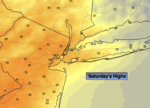
Saturday:
Clouds and sun, much cooler. Breezy. Highs in the upper 60s. Northeast winds at 10-20mph with higher gusts.
Tonight:
Partly cloudy. Much cooler. Lows in the lower to mid 50s in the City, the 40s inland. Northeast to North winds at 8-12mph.
Sunday:
Mostly sunny. Highs in the upper 60s.
Monday:
Mostly sunny. Highs in the lower to mid 70s.
Tuesday:
Partly sunny. Seasonable. Highs in the mid 70s.
Wednesday:
Partly sunny. Highs in the lower 70s.