Synopsis:
Today will be bright and seasonable as May comes to an end. Temperatures will warm rapidly as we close out the week and welcome June. High pressure will sit over the East coast and the airmass will modify considerably. By tomorrow and Friday it’ll feel more like Summer.
A cool front will approach the region Friday night. The chance of scattered thunderstorms has been included in the forecast. Canadian air will work in from New England on Saturday. This will result in cooler readings under a mix of sun and clouds. Scattered showers are possible. Sunday will feature plenty of sun with readings several degrees below thee average high of the mid 70s.
Stay tuned.
Keep it here for a no nonsense, no hype forecast.
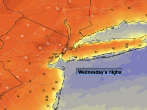
Wednesday:
Sunny. Seasonable. Highs in the mid 70s. Cooler a the coast, warmer inland. Northeast to Southeast winds at 5-10mph.
Tonight:
Mostly clear. Lows around 60º in urban areas, the 40s and 50s North and West. Light Southeast wind.
Thursday:
Mostly sunny. Much warmer. Highs in the mid 80s. Cooler at the coast.
Friday:
Mostly sunny. Hot. Highs around 90º.
Saturday:
Sun and clouds, cooler. Scattered showers possible. Highs in the lower to mid 70s.
Sunday:
Mostly sunny. Cool. Highs around 70º.