Synopsis:
Today will be chilly despite abundant sunshine as a Canadian airmass says hello. Winds will diminish some during the afternoon.
March’s finale on Friday will be tranquil. March will go out like a lamb. Sun will give way to increasings clouds. Showers are possible later in the afternoon and evening as a warm front moves in.
April’s debut will be warm. Showers are possible, especially in the morning on Saturday as strong low pressure moves into the Great Lakes. A balmy Southerly wind will prevail (with readings around 70) and this ain’t no joke on April Fool’s Day. Sunday will be the cooler half of the weekend with another Canadian airmass moving in, at least it’ll be sunny.
Temperatures will rebound nicely on Monday as high pressure moderates and the sun dominates.
Stay tuned.
Keep it here for a no nonsense, no hype forecast.
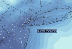
Thursday:
Sunny, breezy and cooler. Highs in the mid 40s. Northwest winds at 15-30mph during the morning and diminishing some.
Tonight:
Clear and cold. Lows in the mid 30s along the corridor, the 20s inland. Light winds.
Friday:
Sun to clouds. Late day showers possible. Highs in the mid to upper 50s.
Saturday:
Mainly cloudy. Warm. Showers threat. Highs around 70º.
Sunday:
Sunny. Much cooler. Highs around 50º.
Monday:
Sunny. Milder. Highs in the lower 60s.