Synopsis:
Tuesday will be a changeable day with more clouds than sun. Spotty showers are possible just about any time as weak upper level disturbances work through. Readings will be a few degrees below the average high of 54º.
Wednesday and Thursday will feature plenty of sun. Near seasonable averages are expected Wednesday. A cool breeze will dominate on Thursday behind a cold front.
March’s finale on Friday will be tranquil. March will go out like a lamb. Sun and clouds are expected with near seasonable readings.
April’s debut will be warm. Showers are possible as strong low pressure moves into the Great Lakes and a balmy Southerly flow takes hold. And this ain’t no joke on April Fool’s Day.
Stay tuned.
Keep it here for a no nonsense, no hype forecast.
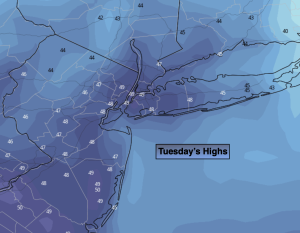
Tuesday:
Mostly cloudy with a shower possible just about any time. The majority of the day will be dry. Highs in the 40s to around 50º. Northwest winds at 5-10mph.
Tonight:
Becoming mostly clear. Lows in the upper 30s in the City, the upper 20s and 30s inland. North winds at 5-10mph.
Wednesday:
Sunny. Highs in the lower mid 50s.
Thursday:
Sunny. Cooler. Highs in the upper 40s.
Friday:
Sun to clouds. Highs in the mid to upper 50s.
Saturday:
Mainly cloudy. Warm. Showers threat. Highs in the lower 70s.