Synopsis
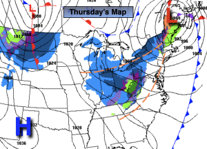
The sun will finally return today as the storm that gave the area a deluge departs into Eastern Canada. Clouds will roll in from time to time. Readings will be several degrees above the average high of the upper 30s. Winds will be busy with gusts up to 40mph . The difference between strong low pressure to our Northeast and strong high pressure in Texas will cause a tight pressure gradient. The map above shows the black lines of equal pressure (isobars), when they are tightly packed it correlates to stronger winds.
By Friday, readings will cool down to near average temperatures as a Canadian airmass works in under mostly sunny skies.
The weekend looks decent for late January. Conditions will remain tranquil along the East coast with once again very mild temperatures as weak high pressure dominates. No major changes are expected for the beginning of the week..
Stay tuned.
Keep it here for a no hype, no nonsense forecast
Thursday:
Partly sunny and windy. Highs in the 40s. West winds at 15-25mph with gusts to 40mph.
Tonight:
Partly cloudy Gusty winds early will diminish. Lows in the lower 30s along the urban corridor, the 20s inland. West winds diminishing to 8-12mph after midnight.
Friday:
Mostly sunny. More seasoanble. Highs in the upper 30s.
Saturday:
Partly sunny. Milder. Highs in the mid to upper 40s.
Sunday:
Partly sunny. Highs in the upper 40s.
Monday:
Clouds to sun. Highs in the mid 40s.